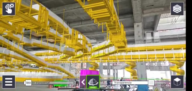
The construction of the Jorge Chávez Airport (Peru), by Sacyr Engineering and Infrastructure, has featured an innovative tool based on augmented reality, allowing the addition of images and virtual elements to a real scenario viewed through glasses.
Thanks to the TrimbleSiteVision software, we can apply virtual Building Information Modeling (BIM) models to the real environment at the construction site to verify the result of the 3D digital model.
Thus, we connect virtual projects with the actual plot of land where the development is going to take place, enabling us to work on the precision of the project to minimize errors, optimize time and resources, aiding in better project planning.
Another advantage is that it promotes greater real-time quality control in the execution of the construction.
This achieves the most accurate possible vision of what we are going to build projected as a "hologram" onto a real environment. Therefore, detailed data is provided for the creation of the final or As-Built model, resulting in a clear improvement in daily tasks at each construction phase.
Carlos Ruiz Miranda, head of topography for this project says that "the implementation of augmented reality in construction will be a consolidated reality in Sacyr's projects within a couple of years. Following the company's policy, the topography department will continue to embrace constant innovation."
This software, for instance, allows us to visualize how the fixed boarding bridges in the hangars, the baggage sorting device at the airport or the VIP boarding area will look like. It’s also capable of performing measurements and checking the properties of the object on-site by clicking on it.
Moreover, not only is it applicable to construction projects but it’s also a powerful tool to detect any potential interferences in the project phase. We have a device that allows us to explain our project to clients, subcontractors, as well as public administrations, and communicate its development.
